PARA Parameters for BINGO processing control
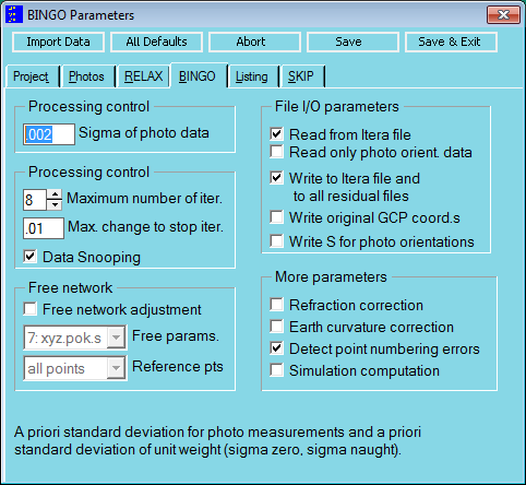
Fig. 6.3-2 Parameters for control of BINGO processing.
Columns | format | contents/explanation |
|---|---|---|
1-4 | A4 | PARA |
5-10 | F5.0 | sx' empirical a priori standard deviation for image measurements and a priori standard deviation of unit weight SXB. Default: sx' = 0.002 |
11-15 | F5.0 | SYF: Factor for a priori empirical standard deviation for y'-components of photo measurements. Default: SYF = 1, i.e.: sy' = sx' This parameter can neither be set nor changed by the GUI only in the file |
16-20 | F5.0 | ABIT: Iteration criterion. If, during iteration, no unknown obtains a correction > ABIT the convergence limit has been reached and the iteration stops. The ABIT value should be smaller than the expected mean point accuracy; otherwise the iteration might be finished too early. Default: ABIT = 0.01 |
21-25 | I5 | MXIT: Maximum number of iterations. The iterative adjustment will be finished after MXIT iterations at the most. 0/-1 :If MXIT = 0 is set in the GUI (or respectively -1 in the file), no adjustment is performed. Then the discrepancies between observations and the approximations of unknowns will be listed as residuals. (See also Section 2.3.2.1)-2 :same as -1, additionally, reading the initial point coordinates from the ITERA file will be skipped. I.e.: only photo orientation data will be read. The point coordinates will be estimated anew by ray intersection. In the GUI the box ″Read only photo orient. data″ must be ticked. Default: MXIT = 8 |
26-30 | I5 | KSNP: Code for data-snooping and variance component estimation 0 :not included1 :included.2 :Computation of the complete inverse matrix for deformation analysis. Caution: very high computation time! This function cannot be activated from the GUI only in the file. Default: KSNP = 1 |
31-35 | I5 | KSIM: Simulation parameter 0 :normal computation1 :simulation computation. No solution vector is computed if KSIM = 1, the approximate unknowns are preserved. Additional parameters are ignored (see also Section 2.4.3). This includes MXIT = 1, if MXIT was not set to -1. Default: KSIM = 0 |
36-40 | I5 | ITIO: Control of input and output to and from the ITERA file. 0 :ITERA file is not used1 :Read from ITERA file2 :Read and write3 :Write to the ITERA file Default: ITIO = 2 For ITIO 2 or 3, as well all residual files will be written. |
41-45 | I5 | ITPT: Controlling the output of the original control points coordinates on the ITERA file 0 :Output of the adjusted point coordinates1 :Output of the entered coordinates on the ITERA file Default: ITPT = 0 |
46-50 | I5 | FTYP: Parameter to activate the free network adjustment. See table below "Selection possibilities for free networks". Range of values 0 -9. Default: FTYP = 0 |
51-55 | I5 | FPTS: Parameter to select the datum points for the free network adjustment. 1 :all object points2 :all CORD statements from the GEO INPUT file.3 :all CONT statements from the GEO INPUT file. In this case the CONT statements will not be effected as control points. Default: FPTS = 1, if FTYP > 0 |
56-60 | I5 | RECC: Parameter to correct earth curvature and refraction 0 :Switched off1 :Refraction correction switched on2 :Earth curvature correction switched on3 :Both corrections switched on Default: RECC = 0 In the GUI, RECC is represented by two checkboxes |
61-65 | I5 | PNER: Parameter for searching point enumeration errors. All point coordinates are compared and points lying very close are listed. Furthermore all skipped photo measurements are examined concerning wrong point names. This is only valid as far as the residuals of the photo measurements are listed. Thus for a complete examination of all photo measurements, the SKIM in the LIST statement will be automatically set to one. Default: PNER = 1 |
66-70 | I5 | ROBI: Parameter for transforming the residuals of the control point photo measurements into the object space 0 :Switched off1 :Transformation switched on for points already listed for other reasons2 :Switched on for all control points Default: ROBI = 1 |
71-75 |
| % |
76-80 | I5 | SITE: Output of standard deviations of photo orientations in the ITERA file. blank:no action1:In every ORIA statement in file itera.dat the standard deviations of projection centre coordinates and orientation angles are output behind the camera name. |
The parameter RECC is in charge of the corrections of earth curvature and refraction at the photo measurements. This option is not generally recommended. For correcting the refraction better results can be achieved in many cases with additional parameters. The earth curvature must not lead to modifications of the photo coordinates, as aerial photos are imaging the curved earth correctly in every case. But the control point coordinates do not follow this curvature in case of e.g. UTM-coordinates. They are "flattened", i.e. falsified. In case of high accuracy demands, the earth curvature has to be corrected at the coordinates of the control points. An "improvement" at the photo coordinates now means leaving rigorous mathematical methods.
For controlling the free network adjustment, the following table indicates the values possible for FTYP and which parameters are therefore carried along as free parameters. With: X,Y,Z= Positioning of the object, S= Scale, Rotations: Φ around X, Ω around Y, Κ around Z.
FTYP | Number of | Free parameters | ||||||
|---|---|---|---|---|---|---|---|---|
1 | 1 |
|
| Z |
|
|
|
|
2 | 2 | X | Y |
|
|
|
|
|
3 | 3 | X | Y | Z |
|
|
|
|
4 | 4 | X | Y | Z |
|
| Κ |
|
5 | 5 | X | Y | Z |
|
| Κ | S |
6 | 6 | X | Y | Z | Φ | Ω | Κ |
|
7 | 7 | X | Y | Z | Φ | Ω | Κ | S |
8 | 3 | X | Y |
|
|
| Κ |
|
9 | 4 | X | Y |
|
|
| Κ | S |
Selection possibilities for free networks | ||||||||
In the cases FTYP=5 and 7, height differences as observation are only allowed if the height difference in relation to the distance of the point is very low, as otherwise these height differences will influence on the scale in an incorrect manner.
Measurement types | FTYP= | 1 | 2 | 3 | 4 | 5 | 6 | 7 | 8 | 9 |
|---|---|---|---|---|---|---|---|---|---|---|
Photo measurements | + | + | + | + | + | + | + | + | + | |
GPS-data | - | - | - | - | - | - | - | - | - | |
Control points X Y | + | - | - | - | - | - | - | - | - | |
Control points Z | - | + | - | - | - | - | - | + | + | |
Coordinate differences dX dY | + | + | + | - | - | - | - | - | - | |
Height differences dZ | + | + | + | + | + | - | - | + | + | |
Distances | + | + | + | + | - | + | - | + | - | |
Sets of directions | + | + | + | + | + | - | - | + | + | |
Zenith distances | + | + | + | + | + | - | - | + | + | |
Azimuths | + | + | + | - | - | - | - | - | - | |
Centring on image stations | + | + | + | + | + | + | + | + | + | |
Stereometric conditions | + | + | + | + | + | + | + | + | + | |
Orientation angles ΦΩ | + | + | + | + | + | - | - | + | + | |
Orientation angles Κ | + | + | + | - | - | - | - | - | - | |
Calibration data for e´ | + | + | + | + | - | + | - | + | - | |
Allowed observation types for networks | ||||||||||
Notes for the free network adjustment
Special problems may appear in very small networks (only very few points). The functionality is always given if a free network contains at least six object points and at least six datum points. For larger networks the functionality is already given with three datum points. In case of problems during a partial track minimisation it is recommended to use all points as datum points.
It will be pointed out that in general the free network adjustment does not include a transformation to the datum points if the parameter FPTS is set to 2 or 3. If a special datum is desired, a transformation should be done (program HEL3D).