5. GEO INPUT file
The GEO INPUT file is like all BINGO files ASCII coded and is used for input of survey measurements and camera parameters for BINGO. Columns 1 to 4 of each input statement contain a keyword which specifies the contents of the statement. The sequence of input statements is normally arbitrary, but is significant.
The input of data is partly effected formatted and partly format-free. In the first case the values have to be entered within defined ranges. Real numbers, such as, for example, coordinates and angles should be entered usefully with a decimal point. Then, for example, values like 37965.4 or 0.03765 may be entered in a field specified as F10.0, in an arbitrary position within the 10 available characters.
To produce this file, a special form file is available, which may be copied into the GEO INPUT file (Appendix B). In this file the round brackets ( ) mean free format and pointed brackets < > mean fix format. Squared brackets [ ] show an optional input for the free format.
Since BINGO 5.4 a special editor called GeoinEdi is also provided for editing this file. It is started from the BINGO manager. Data can be entered or changed in the eight different screens provided. It is also possible to import data – also from files in older BINGO formats.
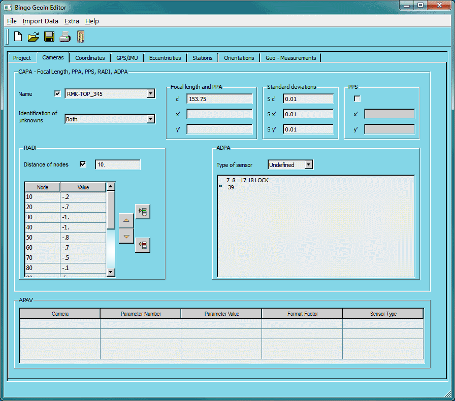
Fig. 5-1 User interface of the GEOIN editor
Weights and standard deviations:
The empirical a priori standard deviation of observations are used for determination of observation weights in the adjustment according to the equation
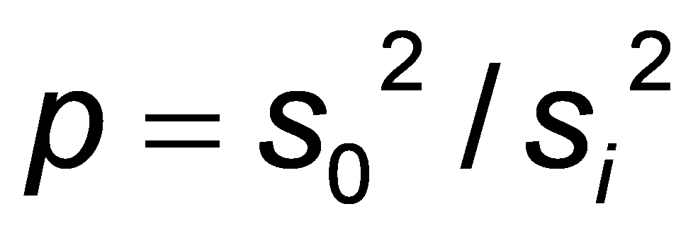
with
s0 :a priori standard deviation of unit weight
(constant in the adjustment, see PARA statement)
si :standard deviation of observation li
If an observation has no standard deviation or if it is zero, then no observation equation is established for that observation, which means that the observation will not be included in the adjustment. Nevertheless, entry of such values may be important if they could also be unknowns of the adjustment, such as control points, camera constants and principal-point positions, as well as for eccentricity vector e'
The given values will then be used in the adjustment as approximations to the unknowns. Camera constant and principal-point position may also be treated as invariable values.
It is of great importance for the adjustment to indicate appropriate standard deviations. In most cases these standard deviations can be determined separately for each observation. Nevertheless, in an observation series different standard deviations should only be used if differences are justified by the measurement conditions or, for example, by the rigour of point definitions. On no account should single observations get larger standard deviations because of larger residuals, in order to avoid an error indication during the statistical test.
In most observation series, a separate a priori standard deviation is not necessary for each observation. If it is missing then the standard deviation of the preceding observation will be applied. A review of those values which are actually used is accomplished by listing the read-in measurements (see chapter 6.3 LIST statement).
In the following an overview about the possible input statements is given:
Name | Contents / Explanation |
|---|---|
5.1 Camera parameters | |
CAPA | camera parameters: constant and principal point |
GRUP | Special weights for groups of cameras |
RADI | radial symmetric lens distortion |
ADPA | additional parameters |
PPSP | position of PPS |
5.2 Point coordinates | |
COES | empirical standard deviation for control points |
CONT | control points |
CORD | approximate coordinates |
CHCK | independent check points |
5.3 Kinematic GPS-positioning, IMU data | |
FILE | Names of the GPS/IMU data files |
GTRA | Transformation parameters from WGS84 to the control point system |
ECCA | Eccentricity vector from the projection centre to the antenna and known IMU calibration angles |
ECES | Standard deviation for ECCA |
EDIS | Length of vector eʹ |
5.4 Weight manipulation | |
GRUP | define groups of points or radial image regions |
5.5 Survey measurements | |
AZIM | azimuths |
DIFX,-Y,-Z | coordinate differences in X, Y or Z |
DISH | distances horizontal |
DIS3 | distances three-dimensional |
SEDI | sets of directions |
ZEDI | zenith distances |
CONS | constants: earth radius and refraction |
5.6 Camera stations and stereo metric conditions | |
ECES | empirical standard deviation for eccentricity data |
ECCA | eccentricity data for a camera |
ISES | empirical standard deviation for image station data |
EDIS | Length of vector eʹ |
ISTA | image station conditions and photo orientations |
SMES | empirical standard deviation for stereo metric conditions |
SMCO | stereo metric camera conditions |
5.7 Initial approximations of photo orientation data | |
ORIA | exterior orientation for aerial photos |
ORIT | orientation for terrestrial photos |
DORI | orientation differences between photos |
5.8 Common data | |
C | comments |
END | end of data |